Example – Scale Isolines
MapAnalyst computes the global scale factor and global rotation for an old map. For example, the map below has a global scale of approximately 1:177,000. The global rotation is around 16 degrees in clockwise direction.
MapAnalyst can additionally generate isolines illustrating local variation of scale and rotation. The isolines in the map below show that the reddish left section of the map is depicted at a scale of approximately 1:175,000 – while the right part has a considerably smaller scale of approximately 1:190,000.
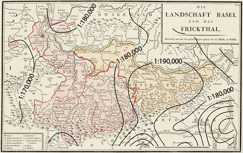
"Die Landschaft Basel und das Frickthal" by W. Haas, 1798, with scale isolines.
(The labels have been added using a raster graphics software.)