Examples
Click on a subchapter on the left to view the graphical output of a typical analysis of an old map with MapAnalyst. The examples use a map of 1798 entitled "Die Landschaft Basel und das Frickthal" by Wilhelm Haas, showing an area in the north of Switzerland.
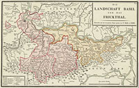
Detailed view of the map.
The example map can be downloaded together with a modern reference map of the same area and with a set of control points used to compute the example illustrations.
The example map is outstanding in its use of movable type for text placement. This "typometric" technique reached a peak of development in the late eighteenth century. For more information about this technique see Harris, E. M. (1975). "Miscellaneous map printing processes in the nineteenth century". In: Five centuries of map printing. Edited by D. Woodward. p. 113-136.